Hurricane Jimena Heads Towards Todos Santos as a Cat 4
August 30, 2009 by jim.pickell
Filed under Blog, Press
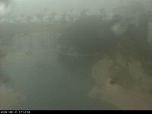
Cabo 4:07pm PDT
“If it were lush and rich, one could understand the pull, but it is fierce and hostile and sullen. The stone mountains pile up to the sky and there is little fresh water. But we know we must go back if we live, and we don’t know why.” – Steinbeck, Log from the Sea of Cortez
Some post-mortem coverage here:
Supplies sent to Jimena victims
KXO Radio
There was only one fatality reported, but thousands were left homeless and without in the Baja California Sur areas of Lopez Mateos, Campo Rene, …
See all stories on this topic
Helping Hurricane Jimena Victims: When Flying Becomes More Than a …
Examiner.com
This weekend, Dave is flying a charity mission to help hurricane victims in Mulegé, Baja California Sur, Mexico. Dave vacationed in Baja California Sur …
Mexico: Hurricane Jimena DREF Operation No. MDRMX003
ReliefWeb (press release)
Branches in the state of Baja California Sur deployed 35 vehicles, and 16 rescue units were also mobilized. 170 volunteers have been involved in emergency …
See all stories on this topic
Support Hurricane Jimena Disaster Relief Efforts in Baja …
By mexiconewsonline
The International Community Foundation is partnering with the Mexican Red Cross to support disaster relief efforts in Baja California Sur caused by Hurricane Jimena. The Red Cross has determined that the greatest needs are found in …
Mexico News Online – http://mexiconewsonline.wordpress.com/
Cabo Marinas Spared, but Hurricane Jimena Hits Baja and Sonora Hard
The Log Newspaper
Hurricane Jimena demolished major portions of central Baja California Sur and parts of Sonora, leaving an estimated 35000 people homeless. …
Most recent update below: Wed, Sept 2, 9:04am PDT (new updates in red).
A major hurricane, Jimena, is passing Todos Santos. The current conditions are about 80 degrees with sporadic rain. Water is 80 degrees plus.Jimena weakens and is now Cat 2. Recent Public Advisory 20 at the bottom of this post.
TODOS SANTOS STILL HAS SOME MAGIC AND APPARENTLY MISSED WHAT COULD HAVE BEEN DEVASTING BUT WE ARE NOT OUT OF THE WOODS YET. DAMAGE REPORT TO COME LATER TODAY.
SINAPROC declares yellow alert for Hurricane Jimena, Category 4. Families should prepare to go to shelters
The computer models are split, with one camp calling for a landfall in southern Baja, and the other camp calling for landfall farther north near central Baja. The official NHC forecast splits the difference between these two solutions, and landfall could occur anywhere along a long stretch of the Baja coast. At this point, the UKMET model’s solution taking Jimena westward out to sea is being discounted, since it is an outlier. The model indicates a 13% the Jimena will hit land near Cabo.
At 11:00 AM PDT the center was at 21.5 degrees north and 111.0 west.
At 500 PM PDT…0000 UTC…the center of Hurricane Jimena was located near latitude 18.8 north…longitude 109.2 west or about 285 miles…460 km…south of Cabo San Lucas Mexico.
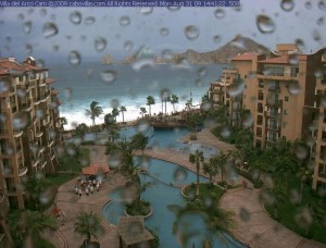
A Hurricane Warning has now been issued.
A HURRICANE WARNING MEANS THAT HURRICANE CONDITIONS ARE EXPECTED SOMEWHERE WITHIN THE WARNING AREA WITHIN 24 HOURS. PREPARATIONS TO PROTECT LIFE AND PROPERTY SHOULD BE RUSHED TO COMPLETION.
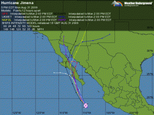
Most Recent Models
Nervous locals are removing satellites, solar panels and covering gaps in doors and windows, many wishing they had storm shutters. They are buying water and food. We’ll monitor the progress a keep you updated here; however, everyone in Todos Santos expects to lose power at some point so communications may be limited after Tuesday.
Jimena is expected to produce total rain accumulations of 5 to 10 inches over the southern half of the Baja California peninsula and portions of western Mexico during the next 2 days…with possible isolated maximum amounts of 15 inches. Much of the damage caused to Baja by prior hurricanes was due to flooding and mudslides.
A storm surge along with large and dangerous battering waves will produce significant coastal flooding along the Baja California peninsula.
Twitter has been a great source of current info. and we keep that more current www.twitter.com/calycanto (or simply search jimena). We’ll also post the Advisories here as they are updated (Advisory 18 13A 13 12 is at the bottom of this post). The current advisories can also be found here: http://www.nhc.noaa.gov/text/refresh/MIATCPEP3+shtml/311136.shtml
“There’s a good chance this system could be a Category 5 in the next 24 hours,” said Dave Roberts, a hurricane specialist with the National Hurricane Center.
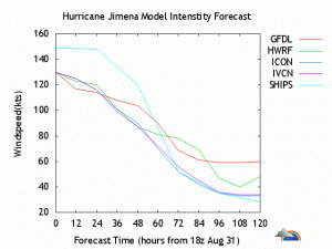
Projected Wind
According to the National Hurricane Center’s model, there’s a 20% to 30% likelihood that Todos Santos will experience hurricane force winds, sustained (1-minute average) surface wind speeds equal to or exceeding 64 kt…74 mph (hurricane force). See www.nhc.noaa.gov/refresh/graphics_ep3+shtml/143526.shtml?hwind120#contents
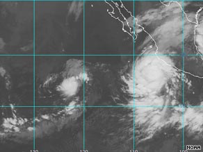
As of Tuesday afternoon, Jimena was located about 70 miles east of Todos Santos Baja California. The storm is expected to continue in a north-northwest motion and approach the southwestern tip of Baja California sometime early Tuesday.
Jimena is the 10th named storm of the Pacific season.
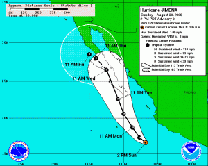
“It started out kind of slow for the Pacific,” said Robbie Berg, another specialist at the hurricane center. “But actually August, now we’ve had seven named storms form, and that’s pretty busy for August. We haven’t seen that — I think it’s been a couple decades since we’ve seen that many storms in August.”
“There’s no watches or warnings in effect, but we would like residents and tourists in the area to monitor the progress of the storm,” Berg said. “We do expect it to maintain its major hurricane strength as it heads up into that area.”
Here’s some good links to track this Hurricane and to read more about Baja Hurricanes:
- http://www.eebmike.com/
- http://icons-pe.wunderground.com/data/images/ep200913_model
- http://www.stormpulse.com/pacific/fullscreen/current
- https://calycanto.com/blog/the-hurricane-season-in-todos-santos/
ADVISORY 20
Hurricane Jimena Advisory Number 20
0000 WTPZ33 KNHC 021436 TCPEP3 BULLETIN HURRICANE JIMENA ADVISORY NUMBER 20 NWS TPC/NATIONAL HURRICANE CENTER MIAMI FL EP132009 800 AM PDT WED SEP 02 2009 ...CENTER OF JIMENA PASSES NEAR CABO SAN LAZARO MEXICO... A HURRICANE WARNING REMAINS IN EFFECT FOR THE BAJA CALIFORNIA PENINSULA FROM AGUA BLANCA NORTHWARD TO PUNTA ABREOJOS ON THE WEST COAST...AND FROM LA PAZ NORTHWARD TO MULEGE ON THE EAST COAST. A HURRICANE WARNING MEANS THAT HURRICANE CONDITIONS ARE EXPECTED SOMEWHERE WITHIN THE WARNING AREA WITHIN 24 HOURS. PREPARATIONS TO PROTECT LIFE AND PROPERTY SHOULD BE RUSHED TO COMPLETION. A TROPICAL STORM WARNING AND A HURRICANE WATCH ARE IN EFFECT FOR THE BAJA CALIFORNIA PENINSULA NORTH OF PUNTA ABREOJOS TO PUNTA EUGENIA ON THE WEST COAST...AND NORTH OF MULEGE TO BAHIA SAN JUAN BAUTISTA ON THE EAST COAST. A TROPICAL STORM WARNING MEANS THAT TROPICAL STORM CONDITIONS ARE EXPECTED SOMEWHERE IN THE WARNING AREA WITHIN 24 HOURS. A HURRICANE WATCH MEANS THAT HURRICANE CONDITIONS ARE POSSIBLE WITHIN THE WATCH AREA...GENERALLY WITHIN 36 HOURS. A TROPICAL STORM WATCH REMAINS IN EFFECT FOR THE BAJA CALIFORNIA PENINSULA NORTH OF PUNTA EUGENIA TO SAN JOSE DE LAS PALOMAS ON THE WEST COAST...AND NORTH OF BAHIA SAN JUAN BAUTISTA TO BAHIA DE LOS ANGELES ON THE EAST COAST. A TROPICAL STORM WATCH MEANS THAT TROPICAL STORM CONDITIONS ARE POSSIBLE WITHIN THE WATCH AREA...GENERALLY WITHIN 36 HOURS. A TROPICAL STORM WATCH REMAINS IN EFFECT FOR THE WEST COAST OF MAINLAND MEXICO FROM ALTATA NORTHWARD TO BAHIA KINO. INTERESTS ELSEWHERE IN THE BAJA CALIFORNIA PENINSULA AND IN NORTHWESTERN MAINLAND MEXICO SHOULD MONITOR THE PROGRESS OF JIMENA. FOR STORM INFORMATION SPECIFIC TO YOUR AREA OUTSIDE OF THE UNITED STATES...PLEASE MONITOR PRODUCTS ISSUED BY YOUR NATIONAL METEOROLOGICAL SERVICE. AT 800 AM PDT...1500 UTC...THE CENTER OF HURRICANE JIMENA WAS LOCATED NEAR LATITUDE 25.2 NORTH...LONGITUDE 112.2 WEST OR ABOUT 30 MILES... 45 KM...NORTH-NORTHEAST OF CABO SAN LAZARO MEXICO AND ABOUT 255 MILES...410 KM...SOUTHEAST OF PUNTA EUGENIA MEXICO. JIMENA IS MOVING TOWARD THE NORTH-NORTHWEST NEAR 13 MPH...20 KM/HR. THIS GENERAL MOTION IS EXPECTED TO CONTINUE WITH A DECREASE IN FORWARD SPEED DURING THE NEXT 24 TO 36 HOURS. ON THIS COURSE...THE CORE OF JIMENA WILL BE NEAR OR JUST OFFSHORE THE WEST COAST OF THE SOUTHERN BAJA CALIFORNIA PENINSULA TODAY...AND NEAR OR OVER THE CENTRAL BAJA CALIFORNIA PENINSULA ON THURSDAY. DURING THE PAST FEW HOURS...THE CENTER OF JIMENA HAS MOVED NEAR OR OVER THE COAST OF MEXICO NEAR CABO SAN LAZARO. MAXIMUM SUSTAINED WINDS ARE NEAR 100 MPH...160 KM/HR...WITH HIGHER GUSTS. JIMENA IS A CATEGORY TWO HURRICANE ON THE SAFFIR-SIMPSON SCALE. WEAKENING IS FORECAST DURING THE NEXT 24 HOURS...BUT JIMENA IS STILL FORECAST TO BE A HURRICANE WHEN IT MOVES INLAND. HURRICANE FORCE WINDS EXTEND OUTWARD UP TO 35 MILES...55 KM...FROM THE CENTER...AND TROPICAL STORM FORCE WINDS EXTEND OUTWARD UP TO 140 MILES...220 KM. ESTIMATED MINIMUM CENTRAL PRESSURE IS 973 MB...28.73 INCHES. JIMENA IS EXPECTED TO PRODUCE TOTAL RAIN ACCUMULATIONS OF 5 TO 10 INCHES OVER THE SOUTHERN HALF OF THE BAJA PENINSULA AND PORTIONS OF WESTERN MEXICO DURING THE NEXT COUPLE OF DAYS...WITH POSSIBLE ISOLATED MAXIMUM AMOUNTS OF 15 INCHES. THESE RAINS COULD PRODUCE LIFE-THREATENING FLASH FLOODS AND MUD SLIDES. A DANGEROUS STORM SURGE ALONG WITH LARGE AND DANGEROUS BATTERING WAVES WILL PRODUCE SIGNIFICANT COASTAL FLOODING ALONG THE BAJA CALIFORNIA PENINSULA. ...SUMMARY OF 800 AM PDT INFORMATION... LOCATION...25.2N 112.2W MAXIMUM SUSTAINED WINDS...100 MPH PRESENT MOVEMENT...NORTH-NORTHWEST OR 345 DEGREES AT 13 MPH MINIMUM CENTRAL PRESSURE...973 MB AN INTERMEDIATE ADVISORY WILL BE ISSUED BY THE NATIONAL HURRICANE CENTER AT 1100 AM PDT FOLLOWED BY THE NEXT COMPLETE ADVISORY AT 200 PM PDT. $$ FORECASTER BEVEN
ADVISORY ARCHIVES
Possibly Related Posts:
- Wizard of Oz – Todos Santos, Baja
- Mexico’s Health Care: First-Rate, and at Bargain Prices
- Press Index
- Beware Airline Surfboard Bag Fees
- Todos Santos Ranked Top Emerging Destination in the World


